Find out about Moruya’s flood future
Eurobodalla Council is inviting community comment on the draft Moruya Flood Study and Floodplain Risk Management Study and Plan, the documents are on public exhibition until Wednesday 10 June 2026.
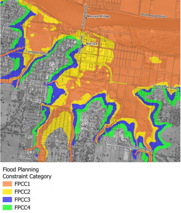
The studies assess flood behaviour and flood risk across Moruya, identifying practical measures to assist with flood management into the future. The study area stretches from the Moruya River mouth upstream to Wamban Creek and includes surrounding waterways such as Dooga Creek, Malabar Creek and Racecourse Creek.
Eurobodalla Council’s director of planning and environment Gary Bruce says the exhibition period is a key part of the planning process, giving residents, businesses and landowners an opportunity to see the modelling before the studies are finalised.
“We’re not adopting these studies yet. Public exhibition is the community’s formal opportunity to look at the work completed to date, ask questions and provide feedback to help shape the final documents,” Mr Bruce says.
The modelling shows flooding remains a significant and complex challenge for Moruya, particularly when flooding, tides, impacts from climate change and road overtopping combine. Some of the towns key transport routes, including the Princes Highway, South Head Road, Albert Street and Murray Street – are identified as vulnerable to major flood events.
“We also identify possible risk-management measures like improved emergency planning, flood warning information, and selective road raising to ensure long-term resilience for the town centre and vital infrastructure,” says Mr Bruce.
Advances in flood modelling and updated rainfall data has led to higher predicted flooding in some areas compared with earlier studies.
“We’re already hearing concerns about how this modelling could affect Moruya’s development, particularly in the CBD. However, the draft documents largely reflect flood controls already in place. This exhibition period is specifically designed so we can hear from right across the community before anything is finalised,” Mr Bruce says.
“These documents reflect almost three years of work with specialist consultant Rhelm, technical agencies and community consultation, and have been reviewed by Council’s Climate and Environment Advisory Committee.”
Council is providing the community with opportunities for face-to-face discussion with Council staff and flood specialists, with two drop-in Sessions at Moruya’s Dr Mackay Community Centre:
* Monday 25 May from 3-7pm
* Tuesday 26 May from 9am-1pm
In addition, there is an online survey available on Council’s Our Eurobodalla community engagement platform. Mr Bruce says there will be targeted sessions with Aboriginal stakeholders including local land councils and Elder groups, as well as emergency services and warning providers like the Bureau of Meteorology and Water NSW.
The draft Moruya Flood Study and Floodplain Risk Management Study and Plan are available on Council’s website, with hardcopies available at the Batemans Bay, Moruya and Narooma Libraries, and at Council’s administration building in Moruya. Submissions can be made online, by email or in writing during the exhibition period.
Community can observe Bay floodplain-risk workshop
Councillors will attend a workshop on Eurobodalla’s Floodplain Risk Management Study and Plan for Batemans Bay next week, ahead of the 26 May general meeting. Starting at 10am on Tuesday 19 May, the workshop is open for community observation.
Councillors can discuss proposed mitigation measures that minimise impact from flooding and inundation on Batemans Bay and surrounds.
The community are invited to attend the Moruya Administration Building’s Council Chamber in person or watch online using Council’s webcast service (live for the workshop), with the understanding this is an observation-only – not an active-participatory opportunity.