Moruya Flood Study put out for exhibition
Council voted last week to put the ‘Moruya Flood Study and Flood Risk Management Study and Plan’ on public exhibition despite calls for deferment from some Councillors Constable, Johnson and Pollock.
Cr Constable was concerned “we haven’t done all the engagement we should have done. I understand the Chamber of Commerce had a proposal put to them for development in Moruya just last week and a lot of work has gone into it. We haven’t engaged with these people that have been risking and putting a lot of money into their plans. I’m concerned this would hold up any potential development for them in an inordinate amount of time” he said. “We shouldn’t make the same mistake that have potentially may in other areas. And engage with significant land owners to make them aware of any studies. “
Dir of Planning Gary Bruce said “The purpose of this report is to engage with the public and landowners. This is not to adopt any of the studies, It is to say we have now prepared them.
‘The controls are largely the same as to what we have now – there’s nothing new in that respect. We need to engage with all parts of the community. And that’s the recommendation.”
Cr Pollock said “we encourage people to explore opportunities and involve professionals at significant cost, particularly around flooding, but in our report we’re quoting a 2012 study that says don’t so anything in Moruya. I don’t see the encouragement of people to put forward plans. It’s a pretty lousy approach. Are you just going to leave it sterilized as it is now?”
Cr Shutz said “I’d rather not go into specific parties, it would be good to go to the entire community to see it. I would prefer to see an extended consultation period.”
Cr Turner added “I’ve just been to flood conference in Qld and agree with Cr Shutz that if the 2012 study and 2025 study says severe increased flood risk, I am not inclined to defer it.”
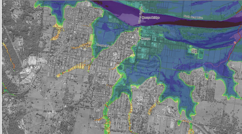
The Flood Risk Management Study and Plan (FRMSP) identifies and outlines proposed mitigation measures to minimise the impact of flooding on the township of Moruya. The Plan outlines works and costings which can then be used for the purpose of applying for grant funding to undertake projects.
“The FRMSP is an important tool in how we plan for the safety of the town and its people, how we manage risk and how we plan for future development.”
Council and contractor have been working on the study for nearly two years.
The objective of the study was to review and update the existing 1999 study, to improve understanding of flood behavior and impacts, and better inform the management of flood risk, in the study area, giving consideration to any available information and the
The Floodplain Risk Management Plan confirms that major transport routes (including the Princes Highway, South Head Road, Albert Street and Murray Street) overtop in relatively frequent events, limiting evacuation, emergency access and service continuity. The Plan prioritises asset resilience and operational continuity, such as improved emergency response planning, selective road-raising where justified, and better flood warning information. It is outlined that Albert St, South Head Rd, Murray St and the Princes Highway are key roads that need raising, and that CBD landform raising should be investigated.
Community consultation will be undertaken through a minimum 28-day public exhibition of the Moruya Flood Study (FS), Floodplain Risk Management Study (FRMS) and Floodplain Risk Management Plan (FRMP). During this period, the documents will be available on Council’s website and for viewing at the Batemans Bay, Moruya and Narooma libraries, as well as the Moruya Customer Service Centre.
Consultation will also include drop-in sessions, community workshops and conversations, and online promotion through social media.
Targeted consultation with key stakeholders, including NSW SES, NSW Health and the local Indigenous community, will occur during the exhibition period. Recent updates to climate modelling, system understanding, and Australian Rainfall and Runoff (ARR19) model inputs have resulted in higher predicted flood levels than those previously communicated.
Consequently, revised flood height data and comparative impact mapping will be made available for the study area during this consultation period.
The flood study and plans have also been presented to Council’s Climate and Environment Advisory Committee (CEAC). Ongoing dialogue and responses to specific questions from the Committee has also occurred.
In conclusion the report said “The Study shows that flooding presents an ongoing and complex risk to people, property, infrastructure and access within the Moruya area, particularly due to the interaction of riverine flooding, tidal influences, road overtopping and climate change.
Importantly, it demonstrates that large-scale flood modification works would provide limited benefit relative to their environmental risk and cost, and instead identifies a suite of practical, defensible and largely non-structural actions focused on planning controls, emergency management, data improvement and community preparedness.”
In an email to Councillors and staff last week, the developers of the proposed multi story development on the corner of Campbell and Vulcan Streets, said “The proposed controls will prohibit any development that increases density in large areas of the Moruya Town Centre. Lots that are currently vacant will not be able to be developed. Lots that are currently underutilised will not be able to be intensified. The Moruya Town Centre will effectively become locked in time.”
The report and hefty study attachments are at https://www.esc.nsw.gov.au/council/meetings/agendas-and-minutes