Concerns over proposed closure and sale of Coopers Island Road
By Alex Rea
First Published MM 3/12/12
A Eurobodalla Council proposal to close and sell a public road reserve known as Coopers Island Road, Bodalla, has raised concerned from the community.
Council is proposing to close and sell Coopers Island Road at Trunketabella, following a Crown Lands survey confirming there is no access to public land or water. Upon closure, Eurobodalla Shire Council proposes to negotiate the sale of the land.
This proposal reverses a decision made in 2021 to keep the road open to the public.
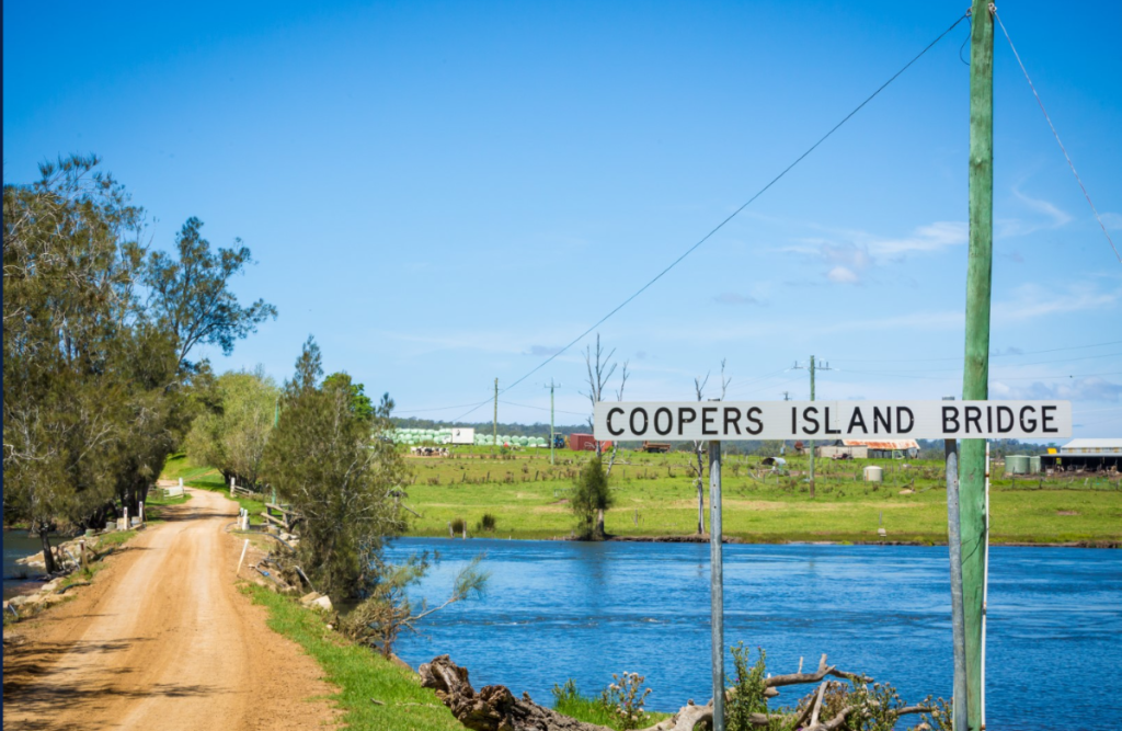
Coopers Island Road had traditionally been used to access the waterway of Bowns Creek for fishing, kayaking and prawning.
In 2017 the property at Coopers Island changed hands and in 2019 a gate was constructed by the landowner at the entrance from the Princes Highway.
In 2021 a dozen concerned residents (some representing larger groups) presented to council on the closure of the road by a gate, installed in 2019.
In June 2021 a report to Council said:
“Coopers Island Road was converted to a public road in the 1930s and is currently a public road. The road is used by the owners to access their property and has been used by the public to access the Tuross Lake system for recreational fishing.
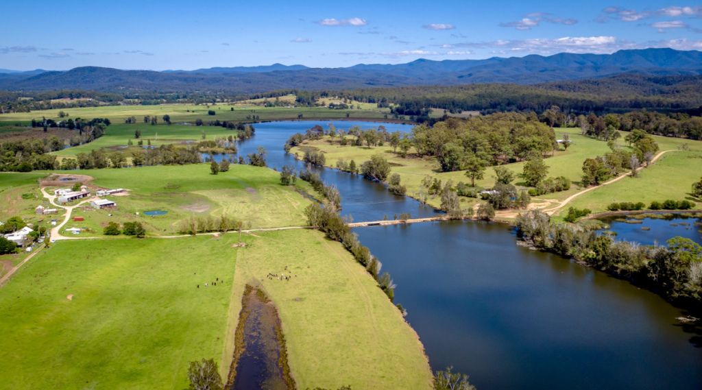
Recreational fishers park near the causeway to fish from the causeway, bank and bridge and to launch kayaks into the waterway. This provides access to a long arm of the Tuross Lake system.
The Department of Primary Industries (Fisheries) has designated the Tuross River and estuary (Lake) as a Recreational Fishing Haven (RFH). The waterway adjacent to Coopers Island Road is part of this designated RFH. RFH, areas largely free of commercial fishing, were created along the NSW coast to provide better angling opportunities for recreational fishers. Money raised from the NSW Recreational Fishing Fee enabled a $20 million buyout to create the areas. These havens also promote tourism and create employment in the local area.
Public access to Crown Waterways over Council owned or Crown Roads
Representation has been received from the Office of the NSW Crown Land Commissioner on 31 May 2021 regarding public access to Crown Waterways over Council owned or Crown Roads which states: ‘Please be advised that the Commissioner is of the view that, as a matter of principle, it is of the utmost importance to retain public access to Crown Waterways over Council owned or Crown Roads, and that those roads should not be privatised to exclude that public access’.”
Also that “The rural zoning of the farmland does not preclude fishers or other members of the public accessing Bowns Creek via Coopers Island Road.”
“The landowner, the fishers and the public alike, must obey the relevant road rules made under the Roads Act and any signs or notices that may be erected by Council with respect to the use of the road.
“These rules make it clear that the users of public roads must behave in a way that accommodates the rights of all other users of the road, subject to any specific requirement to the contrary in the legislation. Hence, the landowner must accommodate the fishers’ right to use the road to gain access to, and to stop and fish on or near, the crossing, and, similarly, the fishers and the public must accommodate the landowner’s right to pass along the road, move machinery along the road and drive stock along the road.
The public road currently consists of the causeway and the bridge and the road reserves. Maintenance of the road and the bridge over Bowns Creek by Council is approximately $4000 to $6000 annually. If the road reserve is sold, maintenance and replacement costs will be borne by the owners. The replacement value of the assets are $389,000.
A MOTION was carried (Crs Pollock/Mayne) THAT Council:
1. Does not close or sell Coopers Island Road to the property owner of Lot 2 DP 12290 as noted in the confidential attachment.
2. Allocates up to $40,000 from the 2020-21 budget to realign the road back onto the road reserve and other associated works to improve safety and the operational management of the property to ensure minimising conflict between livestock and road users.
On 10th November 2025 Council advised “a detailed Crown Solicitors’ investigation has revealed the causeway and adjoining land are privately owned.
Council’s director of finance and corporate services Stephanie Speedy says it makes sense to close the road and transfer ownership to the adjoining property owner.
“Without access to public land and water, there is no community benefit to keeping and maintaining Coopers Island Road,” Ms Speedy says.
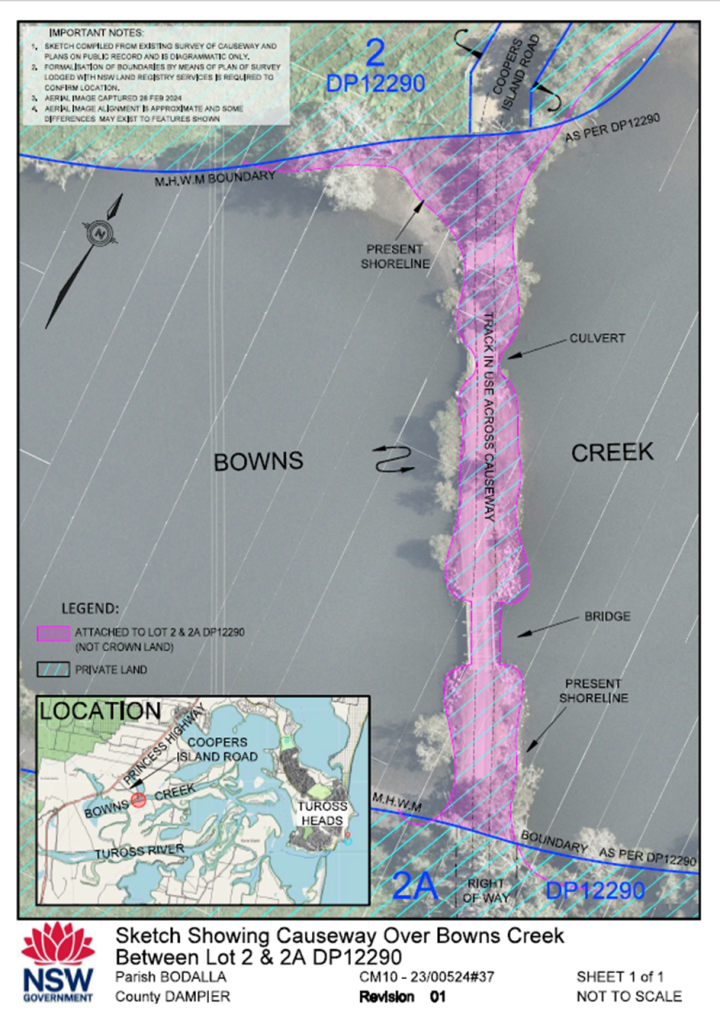
After multiple requests from the public, Crown Lands released a map and explanation for their new advice, that the causeway is not Crown Land.
A spokesperson for Crown Lands in the Department of Planning, Housing and Infrastructure said :
· Coopers Island Road is a public council road managed by Eurobodalla Shire Council.
. Crown Lands completed a detailed historical status investigation to establish ownership of the Coopers Island causeway which determined the causeway was not Crown land.
On background
· Crown Lands has advised Council that:
·The causeway is constructed on land forming the bed and banks of Bowns Creek, which separates Lot 2 from Lot 2A DP 12290.
·The causeway is categorised as a fixture and is owned by the owner of the land to which it is affixed, being Lots 2 and 2A.
·A survey commissioned by Crown Lands confirmed there is no public access to the causeway or Bowns Creek from the Council managed public road Coopers Island Road.
· For fishers, there is fishing access and facilities around the area of Tuross Bridge including a public boat ramp offering access into the river.
· A sketch showing indicative ownership of the Coopers Island Road and causeway site is below: See at left.
Yesterday Crown Lands wrote to a resident saying: “Due to significant public safety concerns at Coopers Island causeway (and bridge), the Department undertook a detailed historical status investigation into ownership of the causeway.”
Council will accept written submissions regarding this proposal until 12 December 2025 at 4pm. Any person is entitled to make submissions to Council with respect to the proposed road closure.
There will be a Public Access forum at Council on Tuesday 9th December and the last Monthly meeting for the year on Tuesday 16th December